Last April 12, 2012, the UN Convention of the Law of the Sea (UNCLOS) recognized and officially approved the Philippines' claim that Benham Rise is part of its continental shelf and territory.
 |
| (source: google images |
What is Benham Rise?
Benham Rise also known as the Benham Plateau (with coordinates 119°3O’E to 132°OO’E and 12°1O’N to 2O°3O’N latitude) is a 13 million hectares under sea region east of Luzon and is 35 meters underwater at its shallowest point off the provinces of Aurora and Isabela. It is said to be wider than Luzon, Leyte and Samar combined.
It is delimited by the West Philippine Basin to the north and east. It is a seismically active undersea region and extinct volcanic ridge east of the Philippines, in the Philippine Sea which lies a number of Basins including the West Philippine Basin (WPB) of which inside the Basin is located the Central Basin Fault (CBF). The Benham Plateau region is located in the CBF and its basement represents a micro-continent. Several scientific survey analysis have been made to study its nature and its impact on tectonic subduction, including one about its effects on the 1990 Luzon earthquake, which devastated the northern city of Baguio.
 |
Andrew E. K. Benham
(source: from google images) |
Why Benham Rise called Benham Rise?
It is actually named after the American geologist Andrew Ellicot Kennedy Benham who discovered the continental shelf. The area was mapped in 1933 but its connection to the Philippine shelf was validated only recently to justify the country’s economic claim. Despite its proximity to the archipelago, the plateau was previously not included in the territory of the Philippine Islands.
It is actually named after the American geologist Andrew Ellicot Kennedy Benham who discovered the continental shelf. The area was mapped in 1933 but its connection to the Philippine shelf was validated only recently to justify the country’s economic claim. Despite its proximity to the archipelago, the plateau was previously not included in the territory of the Philippine Islands.
The Philippine Government's Claim
On 8 April 2009, the Republic of the Philippines lodged a full territorial waters claim with the United Nations Commission on the Limits of the Continental Shelf in relation to the continental shelf in the region of Benham Rise. It was submitted as part of petition expanding the archipelago's baselines and exclusive economic zone through a law that also included other claims involving disputed territories of the Kalayaan Islands (Spratly Islands) and Scarborough Shoal. Although the off shore land form, in itself, is not disputed, the petition still received some criticism inside and outside the country because of its controversial nature.
According to the government's claim, based on a set of guidelines by the Commission on the Limits of the Continental Shelf, the area satisfies the 350-mile constraint line since the outer limits of the continental shelf are located landward of the constraint line, which is located 350 miles from the baselines where the measurement of the breadth of the territorial sea begins. Benham Rise was never a subject to any maritime boundary disputes and claims. The Congress of the Philippines enacted Republic Act No. 9522, also known as the Archipelagic Baselines Law, which is the basis of the claim. According to the document, the region is bounded by the Philippine Basin on the north and east, and by Luzon on the west and south. It asserted that, according to scientific data based on seismic, magnetic, other geological features, the Benham Rise region is an extension of the Philippines’ continental shelf. (http://benhamrise.com/)
With that, the Philippines' territory has also increased from 30 million hectares to 43 million hectares! Aside from expansion of territory, the Philippines will benefit from mineral and gas deposits in Benham Plateau.
Expeditions for the said plateau happened two years ago (2014) but last May 23 of this year, a new team from the Bureau of Fisheries and Aquatic Resources (BFAR), the UP Marine Science Institute, the UP Los Baños School of Environmental Science and Management, and Oceana arrived in Benham Bank.
 |
| source: google images |
According to research, there is a massive mineral and gas deposits in the plateau, and this could help the country to achieve energy sufficiency. Furthermore, solidified methane was found during mapping activities. That is why Benham Rise is believed to have massive oil deposits.
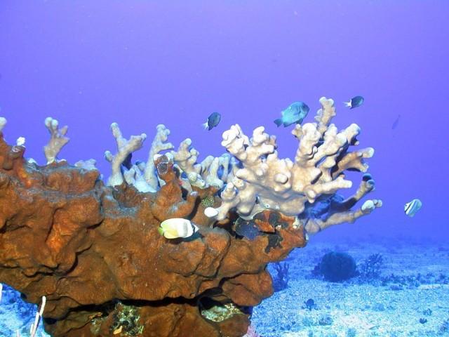
Below are some of the pictures taken during the exploration:
 |
| source: http://www.gmanetwork.com/news/story/568956/scitech/science/scientists-document-diverse-marine-life-of-phl-s-benham-rise |
 |
| source: http://www.gmanetwork.com/news/story/568956/scitech/science/scientists-document-diverse-marine-life-of-phl-s-benham-rise |
 |
| source: google images |
 |
| source: http://www.gmanetwork.com/news/story/568956/scitech/science/scientists-document-diverse-marine-life-of-phl-s-benham-rise |
 |
| source: http://www.gmanetwork.com/news/story/568956/scitech/science/scientists-document-diverse-marine-life-of-phl-s-benham-rise |
 |
| source: http://www.gmanetwork.com/news/story/568956/scitech/science/scientists-document-diverse-marine-life-of-phl-s-benham-rise |
Disclaimer: I do not own any pictures in this blog. The information in this blog was taken from:
1. http://www.update.ph/2016/02/10-things-to-know-about-benham-rise/2766
2. http://www.gmanetwork.com/news/story/568956/scitech/science/scientists-document-diverse-marine-life-of-phl-s-benham-rise
3. http://benhamrise.com/
No comments:
Post a Comment